I wasn't done with looking at woodlands from a mapping perspective in Baden-Wurttemburg. A couple of days after SotM I walked from the top of the gondola at Feldberg to the Feldberg summit and then back to Hinterzarten.
The first part of the walk was somewhat marred by a fierce hailstorm which left me fairly damp. However I recuperated by drying out a bit over Kaffee and Kuchen at the Baldenweger Huette below the summit.
 |
| Forest path, part of the Emil-Thoma-Weg. |
Much of the rest of the walk was through woodland predominantly dominated by Norway Spruce (Fichte, Picea abies), sometimes with fairly extensive patches of Beech (Rotbuch, Fagus sylvatica), with the latter becoming commoner as I got closer to Hinterzarten. So this was a good chance to look at another one of Europe's typical woodland vegetation communities.
Formally these woodlands in the Southern Black Forest are known as Fichten-Tannen-Buchen-Mischwald or the Luzulo-Abietetum under Plant Sociological naming (see German wikipedia and this article for a bit more info). Now, conifers are not that easy to identify, but I think I should be able to spot a Silver Fir (Tannenbaum, Abies ): one of the more useful things is that they have upright cones which stay on the tree, whereas spruce cones hang down and are deciduous. I noticed no firs, and in general beech trees were either sporadic isolated trees or in obvious coherent groups.
Before setting off I'd spent a few minutes viewing the nice exhibition in the Haus der Natur. I snapped a few pictures of various examples of Forest Maps of areas within the National Park. These are interesting as they show the broad range of thematic cartography which is associated with woodlands:
 |
| Forest Ownership |
 |
| Role of forest areas, with particular emphasis on protected areas (habitats, water sources, etc.) |
 |
| Age classes of woodland around the Stauchsee |
 |
| Detail of woodlands around the Feldsee |
The top of the woods were fairly open with a low field layer of bilberry (Heidelbeere, Vaccinium myrtillus). Rowan (Vogelbeere, Sorbus aucuparia) was a frequent component of the understorey, probably in patches where more light was reaching the forest floor. Berries of Rowan are distributed by birds (as its German name implies), usually thrushes. The seeds pass through the digestive tract and thus and may be deposited in woodland away from the source when the bird is roosting or otherwise seeking shelter. Sycamore (Bergahorn, Acer psuedoplatanus) specimens were also occasional in this part of the wood.
 |
| Spruce wood around 1250m asl Note the Bilberry (Vaccinium) field layer and several Rowans (Vogelbeer, Sorbus aucuparia) and a single Sycamore (Berg-Ahorn, Acer pseduoplatanus) in the understorey |
 |
| Ferns and Mosses are obvious where a stream cut through the wood |
 |
| A damp area a little lower down, note small boardwalk on the path. Little or no understorey, but an extensive ground layer. |
The odd Beech tree was apparent at around 1100 m asl. Beech nuts are usually spread by birds and mammals (typically Squirrels, and members of the Crow family such as the Jay and Nutcracker), so there is no reason why isolated trees should not occur (I noticed the same phenomenon in the High Tatra around Zakopane).
 |
| Further down still, Beech trees start appearing: here as a sapling. |
 | |
| Open field-layer dominated by an unidentified herb (possibly Hasenlattich, Prenanthes purpurea) and ferns. There appears to be no Spruce saplings here, and most trunks are of similar diameter. |
Three other types of ground-layer were apparent on the walk back to Hinterzarten. The first was dominated by ferns, and a herb which I was unable to identify. The second appeared to be a relatively recent plantation with next to no ground-layer at all: this is more or less how all Spruce forests (whether Norway or Sitka Spruce) look like in Great Britain. Lastly, there were patches where there were enough Beech trees to leave a layer of leaf litter on the forest floor. No doubt the fact that Beech leaves are slow to rot because they are full of tannin, contributes to the absence of a field layer, as well as the strong shading effect of the living leaves. Close to the village, the forest floor returned to being covered with Bilberry.
 |
| Beech leaf litter is very obvious on the forest floor. Areas with beech become commoner closer to Hinterzarten. |
 |
| Very dense Spruce woodland: there is no ground layer or field layer to speak of This is what most Spruce woods look like in Britain, so I suspect this is a plantation. |
 |
| Close to the village of Hinterzarten the forest is closer to its appearance just below the treeline with Bilberry field layer. |
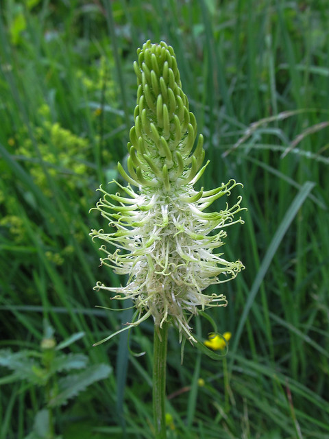 |
| Spiked Rampion - Ährige Teufelskralle (Phyteuma spicata) |
Summary and further thoughts on tagging
I've written a fairly detailed account here as much for my own benefit as for anyone else.It's one thing to look at photos of a wood, another to turn them into a coherent description, or a set of terms suitable for tagging in OSM. The striking thing about these woods was that ,although dominated by the same species of tree, there was obvious variation in the structure and appearance of the woods. These accounts of woods are an attempt to build a small set of suitable examples which can be used to inform how we extend tagging of woods.
I am becoming more convinced that discrete tagging of ground, field and, possibly, understorey can add a lot of useful information about woodland to OSM. Furthermore a lot of the key information does not need any specialised botanical knowledge:
I now believe the core tagging should focus on structural features of these layers (openness, height) rather than their botanical composition, which would then be a secondary component of the tagging. This will lead to a rather extensive set of tags to describe a woodland (at least 2 for each layer of the wood, plus any phytosociological tags, tags describing woodland management, ownership etc., in addition to current tags used to describe broad composition (wood, leaf_type etc.).
However, in contra-distinction to many OSM tags (highways come to mind), trying to impose a single hierarchy of tags describing woodland composition makes tagging of relevant features too hard for most mappers. Furthermore, woodland tagging ought to fulfil a broad range of use cases. My own is concerned with identifying places where I can find particular plants and animals, but there are plenty of others, the one which always comes to my mind is Orienteering, where the structure of the ground and field layers are important.
Separating these components also allows for discrete tagging of woodlands known for their display of spring flowers. In Britain Bluebell (Atlantisches Hasenglöckchen, Hyacinthoides non-scripta) woods are justly valued for their beauty, but other flowers which carpet the woodland floor, such as Wood Anemone (Buschwindröschen Anemone nemorosa), Wild Garlic (Bärlauch, Allium ursinum), and Lily-of-the-Valley (Maiglöckchen, Convallaria majalis) ,are worth searching out in the Spring. For instance, whilst in Germany I learnt of a wonderful site in the Schwäbische Alb, where the latter plant flowers amongst the fruiting bodies of a bright red cup fungus (Scarlet Elf Cup or Scharlachroter Kelchbecherling, Sarcoscypha austriaca or perhaps the related S. jurana), but unfortunately have no links to a photograph.
No comments:
Post a Comment
Sorry, as Google seem unable to filter obvious spam I now have to moderate comments. Please be patient.