This post is the first part of a series amplifying my talk at State of the Map 2013: "Zone de Combat".
Rather like Winnie the Pooh and Piglet wandering around Hundred Acre Wood in search of imaginary woozles we have been going round in circles in the woods. Or is that forests?
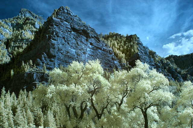 |
| Infrared photo of Cottonwoods in Utah exposes hidden beauty of woodland Cottonwoods by arbyreed, on Flickr CC-BY-SA |
We have a little more than 40 hectares of woodland to care about: there are about 3,425 million hectares of woodland on the globe, covering around 23% of the total land area.
Since I got involved with OSM, 4 and a half years ago I've seen the mapping of many other objects has achieved a very fine level of detail. We can lovingly worry about the minutiae of mapping busbars in power sub-stations, or whether pubs have stone floors and real fires, or which king or queen was alive when a post box was built, or the number of flames in gas lights. These demonstrate that we are perfectly capable of mapping a lot of detail.
On the other hand there are many things where we have failed to delineate important distinctions when we map them. This is particularly true for woodland where we have two widely used tags which are virtually synonymous (landuse=forest and natural=wood). The problems have been rehearsed endlessly on the Wiki, and on OSM Help, so we have a pretty good handle on them, but there has been little concrete action. I think we have argued too long about the respective semantics associated with forest and wood. And, by the way, I'm as guilty as anyone else.
To coin a phrase "we have not seen the wood, or forest, for the trees".
Is it too much to hope that we can make the tagging and representation of woodland just a little bit better and more realistic? This is what this post is about.
I'll start with my perspective on how the wood/forest dichotomy arose, then using a couple of case studies talk about the kinds of things we may want to capture about woodland, and lastly how that information might be presented cartographically.
A little about terminology
As both wood and forest already are loaded with semantics in an OSM context I have chosen to use the term "woodland" which is used by British botanists and conservation bodies to cover the gamut of places covered by trees.A word of caution about this usage: in other countries in Europe the word used is more likely to be cognate with forest, for instance the "Inventaire National des Forets" maintained by the IGN in France; furthermore my botanical dictionary defines the term as:
"1. A vegetation community that includes widely spaced, mature trees. The tree crowns are typically more spreading in form than those of forest trees. Crowns do not touch and do not form a closed canopy. Woodland is defined as having 40 per cent canopy closure or less. Between the trees, grass, heathland or scrub communities typically develop, giving a park-like landscape".Therefore the term is used here solely for the purpose of avoiding potential issues of confusion with terms already used in OSM. This is not too different from the EUNIS definition:
"Woodland and recently cleared or burnt land where the dominant vegetation is, or was until very recently, trees with a canopy cover of at least 10%. Trees are defined as woody plants, typically single-stemmed, that can reach a height of 5 m at maturity unless stunted by poor climate or soil. Includes lines of trees, coppices, regularly tilled tree nurseries, tree-crop plantations and fruit and nut tree orchards. Includes Alnus and Populus swamp woodland and riverine Salix woodland. Excludes Corylus avellana scrub and Salix and Frangula carrs. Excludes stands of climatically-limited dwarf trees (krummholz) less than 3m high, such as occur at the arctic or alpine tree limit. Excludes parkland and dehesa with canopy less than 10%, which are listed under sparsely wooded grasslands E7."
A Fairy Tale or Just-so Story
I was going to try and cast the issue as a fairy story, but my attempts just confirmed what I have known since the age of 5: I am hopeless at creative writing. So please imagine lots of witty references to, inter alia: the Brothers Grimm, As You Like It, Kipling.The basic confusion
Broadly the basic confusion is rooted in the structure and history of woodlands in Great Britain. |
| Yews in Kingley Vale, an extremely rare woodland type in Europe Jim Champion [CC-BY-SA-2.0], via Wikimedia Commons |
 |
| Sherwood Forest, perhaps perceived as an archetype of lowland broad-leaved woodland in Britain By Immanuel Giel (Own work) [Public domain], via Wikimedia Commons |
To make matters worse, the Ordnance Survey 7th series (and some NPE) one-inch maps distinguished between coniferous and broad-leaved woodland. (I'm not sure when this convention was introduced as it does not appear on some of the earlier NPE series). The OS tried to remove this when they introduced the Landranger 1:50k series in 1974, but the outcry against this change was so great that they soon back-tracked.
 |
| A former part of Sherwood Forest around Carburton on NPE maps Both symbols for coniferous and broad-leaved trees can be seen. |
One last awkwardness is that Britain also has only one native evergreen broad-leaved tree, the Holly. This does not form woods, although it will form small clumps, known as shaws. Therefore we also tend to conflate deciduous with broad-leaved trees.
Apart from Iceland, the Faeroes and Ireland, Great Britain is the least wooded place in Europe. Its tree flora is impoverished because many species could not cross the English Channel once it formed after the last Ice Age. It therefore never represented a good baseline for mapping the wide range of woodland types found around the world.
Why is it a problem?
This problem became an issue for me when I started to map Larch woodland in the Alps, and Holm and Cork Oak woodland in Iberia. These are just some examples of woodland where the coniferous/deciduous dichotomy just doesn't work (as indeed is true for tropical rain forests).Many of my favourite locations in the Alps have extensive stands of larch, and they have a completely different character from the more usual spruce woodland: particularly in Autumn and Winter. Places like the Lötschental, the Ober Engadin around Sankt Moritz, the Vallée du Lys, and the Vallée de la Guisane above Briancon are well-known for their fantastic Autumn colour. Furthermore different species of larch extend right across the boreal climatic zone of the Northern Hemisphere. In Siberia and Kamchatka they are the dominant trees extending over huge areas of the landscape. If we can't tag larch woods sensibly then our tagging scheme is pretty rotten. I'll return to Larch woodland in more detail in a later post.
These are my own petty mapping interests. More worrying to me, is that the current tagging and cartography of woodland actively discourages naturalists and conservation workers from using OSM. In many places either one or the other, sometimes both, are just wrong. If you are interested in the details of woodland this tends to stand out as a glaring fault: perhaps akin to mapping footpaths as residential roads. This in turn must lead to the perception that OSM is not a serious tool for their purposes.
I know plenty of botanists, naturalists and conservation workers who use OSM on their Garmins for navigation when carrying out surveys. Perhaps a few contribute to the map, but so far we have not built up a community of any size to map vegetation and biotopes. My belief is that, unless we improve the way we tag and render woodland, we will fail to attract this group of potential contributors. In the UK there are around 50,000 people who regularly contribute some observations of fauna and flora to local or national recording schemes. For instance the recent BTO Bird Atlas has observations from over 17,000 volunteer contributors. Most of these people have extensive experience of crowd-sourced data projects using maps, and will tend to know particular parts of the countryside extremely well. In many areas existing maps will not show the type of detail in which they are interested, for instance the BTO Common Bird Census techniques require annotating a large scale map with symbols representing actual locations where a given bird was seen or heard. I would like OSM to be attractive to such people, not just as a base map, but as a suitable platform for recording the data required for such surveys.
Other tagging problems
There are a couple of related tagging problems which affect mapping woodland, but are probably more significant in general treatment of landuse/landcover.- Misuse of landuse=forest for administration boundaries. This is a particular problem with the US where the areas of land under the control of the National Forest Service have often been imported with landuse=forest tags, even if in practice they are ski areas, bare mountain tops and meadows (see below). The solution here is relatively simple, NFS lands should be re-tagged to show that these are administrative units. This is much less contentious as much of the data was imported and an automated edit process is a reasonable way to deal with the problem.
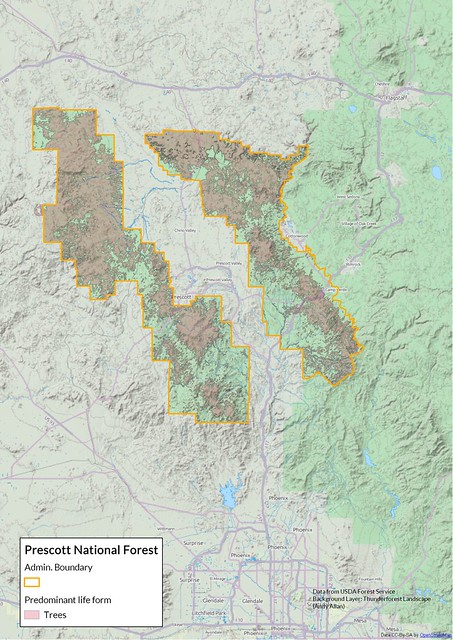 | |
| Prescott National Forest showing area within boundary actually covered with trees. Source: USDA National Park Service. |
- Trying to solve the problem with new tags. There are a number
of alternative ways of tagging which have been suggested and some have a
high degree of popularity. Two keys in particular have caught my eye: landcover and trees. There is nothing wrong or objectionable about
either of these as ideas. The problem is first that it results in
fragmentation of tagging, and even less coherence. Second, it does not
address the issue, which is that most users do not really care over much
about the nitty-gritty of mapping woodland. It is apparent that many
tags which relate to landcover have been adopted because they change the
way data are rendered: landuse=grass in the countryside, landuse=meadow for improved grassland used for pasturage, natural=sand on golf courses, and many other examples.
I see no reason why landcover and trees tags will not be co-opted in the same way.
I have also shown that by comparing European Environment Agency data with OSM, that landcover mapping with tags widely used in 2011 could produce an equivalent level of detail to the EEA Urban Atlas (UA) product (SotM-EU Vienna). The only feature of UA which I couldn't reproduce was the density of built-up urban areas, so our tagging at the time was adequate for analytical purposes.
I doubt if the same is true today because of the widespread use of landuse=grass in farmland and in urban areas. In other words the information content of OSM data has been degraded in this area. This type of problem can be fixed, but by providing much more guidance for mappers, mapping specific areas very carefully to provide good examples, and reducing over-interpretation from aerial images.
In summary, the consistent application of available tags is likely to bring more benefits than creating new tags.
What might this information be used for?
I don't really feel I have to justify why we should tag things more accurately, but it is worth noting some of the more obvious potential uses for providing more information about the nature of woods and forests: I'll stick with Larch woodland for most of my examples. |
| Stazerwald, a larch wood, in Autumn View of the Upper Engadin from the Segantini Hutte Source: Wikimedia Commons. |
- Scenery. The type and quality of woodland affects our perception of places. Often this is at a subconscious level, but not infrequently these qualities are an explicit part of the attraction of a place. Autumn colour in New England, Giant Redwoods in California, Old-growth Oak forest at Białowieża, Golden Larches in the Engadin.
- Wildlife (Natural History). Each type of woodland tends to support it's own characteristic wildlife. This is usually most noticeable in terms of flowers and birds. Staying with larches, these include the Nutcracker, a crow whose use of larch seeds as a food store is intimately related to how the wood propagates. There are also tiny caterpillars which live in a sac and eat the inside of the larch leaves. Thus knowing where a particular type of wood is located is often the best way to find these creatures.
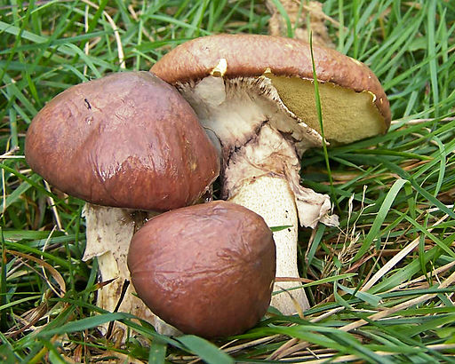
Slippery Jack, a larch-associated bolete - Foraging and Hunting. Really a subset of the above. Wildlife resources are also used for food, and sport. Every mushroom enthusiast knows that particular fungi are only found in association with specific trees. A classic example is the bolete "Slippery Jack" Suillus luteus, which is a larch-associate and a popular edible mushroom in Eastern Europe. To my surprise, it is also found in dried mushroom preparations in British supermarkets.
- Conservation. Larch woodlands in Europe are under threat from a variety of sources according to the EUFORGEN. These include: genetic intermixing with non-native larches used for commercial forestry, climate change, reduced habitat through increased avalanche protection, and the disease Phythophora ramorum. Even though national inventories will have identified all the major woods it is still possible for the amateur to find things which have been missed, or to spot changes more quickly. A re-assessment of the UK Forest Inventory last year resulted in a change of 8%: there's plenty of additional data to collect.
- Fire Risk. Forests burn. How they burn depends on a number of factors, but the type of trees, the leaf-litter and brash they produce, and how they decay are important. As in many disaster scenarios, OSM is at its best when it provides accurate maps in advance. Certainly recent experience with fires in Colorado suggests that its difficult to track the situation once a fire is present.
- Hydrology. One of the most useful uses of landcover tags is that they enable modelling of hydrology. I don't think anyone has done this in earnest, but it is eminently practical, for instance using the BASINS software from the US Environment Agency. It may be that using different woodland types may only fine tune models for flooding or pollution. When I've read this report I might know more!
- Biomass. Most national forest inventories are particularly geared up to measuring biomass: mainly as a means of assessing the potential for timber extraction. However the same techniques also obviously provide a baseline for understanding how much carbon forests sequestrate. The techniques involved are quite elaborate so this type of data is unlikely to be available from OSM in the near future.
 |
| Large Larchborer (Ips cembrae) a pest of European Larch |

How do we begin to resolve the basic tagging problem?
The basic resolution is already documented on the wiki. We stop using wood=deciduous and instead use deciduous=yes and wood=broad-leaved for the vast majority of woodlands affected. This is a non-trivial change: there are nearly quarter of a million polygons tagged with wood=deciduous.This change of approach needs to be supported in two places: editor tools, such as Potlatch 2, Josm, and iD; and in the main cartographic renderings (Mapnik, CycleMap). Andy Allan has already taken significant strides in improving the general cartography of woodland, but still uses wood=deciduous as a synonym for wood=broad-leaved. An approach taken with various Corine imports was to use an alternative tag trees=broad-leaved. For now this is probably the best tag to use to avoid further ambiguity, but see my remarks above about tag proliferation.
These synonymies will have to be tolerated for a long time. However, we have to make a start and this seems to me the appropriate place.
No comments:
Post a Comment
Sorry, as Google seem unable to filter obvious spam I now have to moderate comments. Please be patient.