Wednesday 24 April 2013

Segmentation of Retail Landuse: why do Germans only map shops?

de_retail_karlsruhe
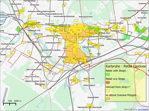
Retail Landuse in Karlsruhe on OSM (scale 1:50k) :
both explicitly mapped and derived landuse polygons are shown, see below for methods.
The availability of lots of open data on various kinds of retail outlets has led to me doing a lot of maps of shops, restaurants, fast-food outlets and bars lately. I'm following in the steps of Paul the Archivist who mapped the Mansfield Road area close to pub meetings we had in 2011. I've got a nice workflow : I map my target area for an hour on Sunday morning, usually trying to get all retail establishments in a quite small area. I also try and collect as many house numbers as I can. I discovered my new mapping protocol, because my mother asked me to drive her to church a few weeks ago and I found it very productive. It also means I've been actively surveying in a neglected inner-city area.


Wednesday 3 April 2013

Maps for Dogs, or Lamp Posts in chains

Public Art-Wet Lamp Post
Wet Lamp Post, photo by Don3rdSE (all rights reserved)
Not more stuff on street lights, 'fraid so.

In my earlier post I mentioned that it would be nice to see if it was possible to find the location of streets simply by linking together all the lamp posts on the same street. This is a (technical) account of how I achieved this using PostGIS.