Another post from the past, not much map content really.
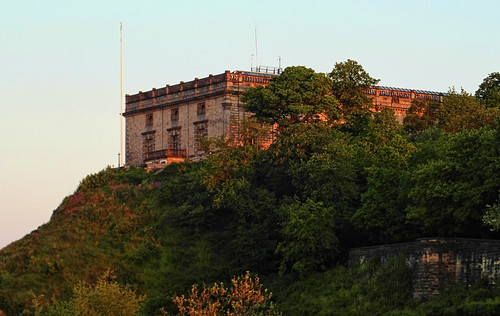
Newcomers arriving in Nottingham by train are often disappointed that the squat box perched above the railway line does not resemble their idea of Nottingham Castle. The reason why it does not look like the Hollywood image are rooted in some significant events of English history.
The Castle was the site where Charles I raised his standard at the start of the English Civil War. Victor's justice meant that the mediaeval castle was slighted (effectively demolished) soon after the end of the Civil War. In it's place the Duke of Newcastle built a
'palace ... [which] looks ... as if it stood in north Italy or Praque" (Pevsner (1979: 226), Buildings of Nottinghamshire).
In 1831 this building was burnt to a shell during the Reform Act Riots, and remained as such until 1875, when the building was restored as one of the earliest municipal museums in Britain.
I'd always known about this event, but knew little of the detail. I therefore persuaded my father to join me on a guided walk about the tumultuous days of 1831. The walk was organised by People's Histreh a group of local people interested in radical history.
We joined the group outside St. Peter's Church on the May Bank Holiday of 2011. To keep us together someone had a large loaf impaled on a stick. Apparently this was one of the codes that a riot was impending. Another signal was to grab whole cheeses off market stalls and roll them in the street. (Nottingham had a "Great Cheese Riot" in 1766).
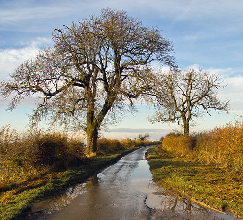
The route followed is shown above. Abbreviated audio of the talks given can be found here and here on Youtube. The embedded video gives feel for what the walk was like, with the early part of the talk by Phillip,an excellent guide.
One of the advantages of failing to finish writing blog posts is that one event overtakes another. In August 2011, Nottingham, like many other English towns, had sporadic events of rioting. At the time I mapped the locations of people brought before the courts for offences connected with rioting:
I'm not sure that any specific lessons can be learned from this plot: locations of riot damage might make it more informative. Unfortunately I don't have either the data or a useful map of 1831 to do something equivalent for the Reform Act Riot.
My impression is that people had travelled quite a distance from their home addresses to the places where riotous events took place. Earlier riots in Nottingham, such as those of 1981 in Hyson Green were much more localised.
In the area of Zurich where I used to live (Kreis 4, Aussersihl) it is still traditional to have a riot every 1st of May. Sensible people get out of town.
and another:
The 2011 riots in England were seen as an exceptional event motivated by "sheer criminality". However, any serious consideration of riots must take them as a recurrent feature of any urban environment: whether they be motivated by poverty, political unrest, or the dynamics of crowds.
Changes:
Jan 2016: replaced Geocommons embedded map with same data moved to Umap.
Before SOTM-EU 2011 I wanted to spend a bit of time in the Alps. This is a belated account of that trip.
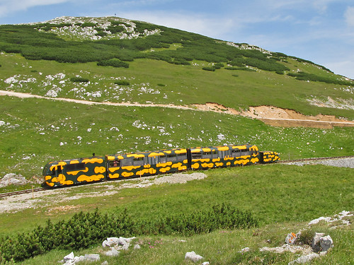
Salamanderzug near the top station.
It's been a few years since I've been anywhere in the Alps in Summer, and in the meantime I've improved my botanical knowledge enormously. So high on my list of things to do was to look at alpine flowers properly for the first time. This is pretty much incompatible with serious hiking: botanising takes time, it's eminently possible to travel at about 100 metres/hour.
I therefore wanted somewhere close to Vienna with mountains high enough to have an alpine flora still in flower, and some kind of mechanical uplift. The obvious choice was the Wiener Hausgebirge, groups of limestone peaks reaching over 2000 m about 50 km SW of Vienna I've known about this area for a number of years: when my brother lived in the Viennese suburb of Meidling, I went skiing on a local hill, the Zauberberg at Semmering. At that time I noted the peaks of the Rax-Schneeberg area from the wonderful switchback railway over the Semmering pass.
The village of Puchberg-am-Schneeberg is still a popular day-trip destination from Vienna, but in the past was a small spa resort. There's one large hotel and a smattering of smaller places. I stayed in the Bruckerhof which turned out to be a nice place in a good location at a great price. It is only a couple of hundred metres from the station, and set back from the main road.
Puchberg was pretty quiet in the evening. I had the impression most visitors were, like the guests in my hotel, of a certain age. I was troubled that I'd have difficulty finding a place to eat, as most people seemed to have dined by half-past six. However, the Schwarzer Adler not only did food, put had a proper pub-like atmosphere down to guys playing cards at the Stammtisch.
With an altitude range of around 1500 metres from the village at just under 600 m to the summit of the Klosterwappen on the Schneeberg at 2076m there was a huge range of interesting habitats to explore. The only downside was that most of the lowland hay meadows had just been cut: so I missed out on some obvious places to botanise. On my first afternoon I wandered (very slowly) up the zigzag track through pine woods to the little peak of the Himberg.
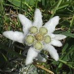
Edelweiss (Leopondtidum nivale)
The following morning I caught the Salamanderzug up the mountain. Even from the train there were special (and protected) flowers to be seen: Martagon Lily Lilium martagon (Türkenbund), Nottingham Catchfly Silene nutans (Nickendes Leimkraut), and Carthusian Pink Dianthus carthusianorum (Kartäusernelke). On the plateau the highlight was Edelweiss (Leontopondtium nivale) and masses of Mountain Avens Dryas octopetala (Silberwurzen). The latter gives its names to stages of the post-glacial Quaternary, so it's more than a pretty flower.
What has this to do with maps? Well the whole area around Puchberg and the Schneeberg itself are great exemplars of the sort of habitats (strictly biotopes) of the kind I would like to map.
Walking up the path to Himberg, I started in woodland dominated by Austrian Pine (Pinus nigra ssp., Schwarzkiefer), but on the northern side of the hill, this graded in Spruce Picea alba woodland (Tannenwald). Further along there were areas of Beech woodland (Buchenwälder). These are very noticeable: the pine wood has much more light than the spruce wood, and very different plants in the under-storey. Beech woods are different again. The plateau of the Schneeberg was a mosaic of grazed areas with a wide range of herbs and sub-shrubs (Mountain Willows, Mountain Avens, Dryas octopetala; Rose), and extensive areas of Pinus mugo scrub. These can be seen behind the train in the picture at the head of this entry. On the steeper sides of the Schneeberg, flushed areas within the Pinus mugo scrub had different plants again, such as Water Avens and . These were frequented by Fritillary butterflies. The scrub grades into forest, but at around 1000 metres there were many hay meadows, again with a different flora: it was around that I saw Martagon Lily.
The Schneeberg is also an important water catchment area for Vienna. There are a number of limestone sink holes in the summit area from which the general public is excluded to avoid polluting the supply. Again this is a feature which is still difficult to map in OSM.
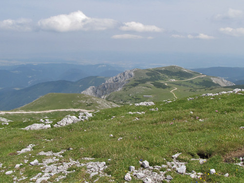
From near Klosterwappen looking across Ochsenboden
The official map made by BEV doesn't do a bad job of showing some of this information, despite really being a 1:50k topomap. It has a lot of toponymic detail, maps the Pinus mugo scrub, shows a lot of detail of the NE-face. It doesn't attempt to separate out the different forest biotopes: this is something I think is an eminently practical thing to do in OSM. The Schneeberg area is a great place to start.
Another aspect of the Schneeberg is that the NE face offers fantastic opportunities for spring skiing. I discussed this briefly with Felix Hartmann (extremecarver) after SotM-EU, who knows this area well. These are extremely well known, but not mapped on OSM. We don't have a sensible way to map this kind of ski route, nor for labelling features such as chutes, couloirs and gullies.
Ash Dieback is a tree disease which has been affecting European trees for over a decade. It hit the news in Britain when it was detected in many places last Autumn.
As this is a blog about maps, I won't dwell on the supine official response to this disease as a threat or once I arrived. Peter Marren guesting on Mark Avery's blog covers the important ground.
What struck me was this map in the Economist in an article about the disease (I'm not the first to use the Ashes to Ashes line from the Book of Common Prayer). It's quite a nice map, lots of information, pleasant muted colours etc. Unfortunately it's complete bollocks as a map of the distribution of Ash trees.
The clue lies in the the oddly shaped blank area near the border of Wales. I instantly recognised the shape of the traditional/historical county of Worcestershire. It is extremely unlikely that Ash trees exist in all the surrounding counties but not in Worcestershire. So it's unlikely the map is right.
There are some other suspiciously blank areas including Nottinghamshire (which would be a surprise to Neil Pinder), and an area North of London which actually has a disease record. So what's going on?
I had only to look at the map to know where The Economist sourced it's data, because there is only one source where data exists for some counties and not others. This is the Botanical Society of the British Isles online research database. To quote "Because this is research-level, live data it may not be appropriate for the general public or for consultancies." And that, The Economist, includes you.
The BSBI Distribution database is used by BSBI recorders who are organised at the county (strictly vice-county) level. They can add their data to the central database or not. Obviously the recorders for vice counties 20 (Hertfordshire), 37 (Worcestershire) and 56 (Nottinghamshire) have not added their recent data. Other places in Scotland and Ireland don't have many botanists: indeed the official recorder for the Outer Hebrides lives in South Wales, and that for Mull in Cambridge. So the map above is more accurately a map of BSBI recorders and their technology preferences. Not the best map to choose.
It gets worse. The public face of the database allows two options: distribution mapped at 10km squares (such as SK53) or 2km squares (called tetrads in Britain). The 10km square distribution data is not as up-to-date but is much more robust because it includes all records used in the major published atlases of British plants: The Plant Atlas and The New Plant Atlas. Here is what the distribution of Ash looks like at the 10km square level:
Ash distribution by 10km square (BSBI)
This shows that Ash is ubiquitous with the minor exceptions of Shetland, parts of the Outer Hebrides and the far North of Scotland.
If we look at the tetrad data including the default date partitioning, not only are the gaps obvious, but also the way the datasets for individual vice counties have been loaded at different times. For instance data for Oxfordshire are there, but are of rather antique. Thus the tetrad maps tell us far more about the internal processes of plant distribution mapping by the BSBI, than they do about Ash trees. (This is a common problem with most biological recording: the maps show where mappers are not where insects or plants or fungi might be found).
In order to display the data in a way closer to the original map from The Economist I've shown the data without date class partitions in the lower of these two maps:
Given equal access to the two datasets the creator of the graphic in The Economist clearly chose the one which looked prettier (FSVO...), rather than the one which was accurate. This is probably symptomatic of the ash dieback disease as a whole, with government bodies (Forestry Commission, DEFRA, etc.) all preferring the wind-blown arrival hypothesis over the importation hypothesis. The former is much more convenient to let the official bodies off the hook: but there is only circumstantial evidence in its favour. The alternative that the disease arrived in imported plants has a substantial material evidence base. Occams' Razor anyone?
I came into England with Oak, Ash and
Thorn, and when Oak, Ash and Thorn are gone I shall go too.
Rudyard Kipling, Weland's Sword from Puck of Pook's Hill
SK53 received a Garmin GPS as a Christmas present in 2008. Foolishly he downloaded OSM, noticed a nearby street was missing, and promptly sold his soul to mapping. Since then he has mapped large parts of Nottingham, verified about half of Maidenhead, takes a PC on holidays for mapping, and now has 2 more GPS gadgets, but still feels the need for more. Further details on his OSM wiki page User:SK53